|
Project Overview
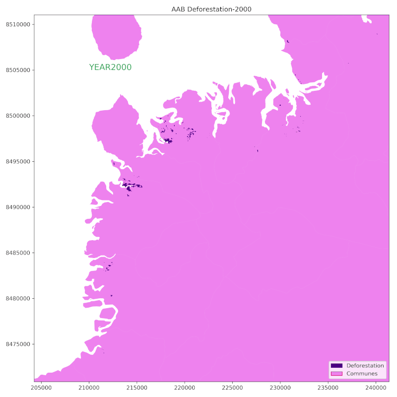
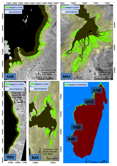
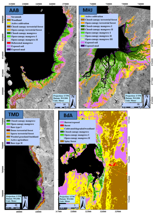
This project focuses on Ambaro-Ambanja Bays (AAB) in NorthWest Madagascar. It is an incredibly bio-diverse coastal area wherein mangrove deforestation has increased exponentially over the past 25 years. In this project I explored existing national-level mangrove distribution data-sets produced by the USGS from three dates (1990, 2000,2010). Then I used this multi-date distribution data to quantify deforestation and examine the change in extent of mangrove forests. Why USGS datasets? Based on comparison with existing datasets, the mangrove datasets produced by the USGS are the most comprehensive and contemporary estimates of the mangroves of Madagascar. They were the only ones to provide the most recent/contemporary distribution that focus solely on mangroves. While confusion with other vegetation classes (e.g., terrestrial forest types) was mostly avoided, the USGS map under-represents mangrove stands which are naturally lower stature and more open or highly degraded, and it completely omits most scrub/shrub-dominated areas and certain narrow linear strips. The under-representation results in conservative distribution estimates, and this in turn impacts ranking primary mangrove ecosystems by extent, as shown in the study. Mahajamba Bay (MHJ) was estimated as Madagascar’s largest mangrove ecosystem based on the USGS map; whereas the study’s AOI-specific map indicates that Ambaro-Ambanja Bay (AAB) was slightly larger. Field observations showed that certain areas appearing as loss in the USGS maps were actually sparsely grown or degraded mangroves. Deforestation- Loss, Persistence and Gain Analyzing imagery from 1990 to 2000 to 2010, it categorized the changes that occurred on the amount of available mangroves into three, namely; loss, persistence and gain. Loss is the total net loss or the amount mangroves area lost per hectare across the said period. Persistence is the amount of mangrove area per hectare that stays the same across the analysed period, this happens to be the most because most areas stayed the same as shown by the statistics and the maps. Gain is the total net gain or the amount of mangroves area gained per hectare across the said period. This happened to be the smallest out of the three criteria, because more mangroves was lost than was gained across the period under examination. Connection between mapping and modelling of deforestation and ecosystem loss to sustainable management and carbon initiatives. There is a growing body of evidence that mangroves are amongst the most carbon-dense forests in the tropics, with similar above- and larger below-ground stocks than terrestrial tropical upland systems. As such, mapping and modelling ecosystem loss directly impacts sustainable management and carbon initiatives such as REDD+ (reducing emissions from deforestation and forest degradation in developing countries). It allows the principal actors to identify the critical importance of mangrove forests to the various carbon initiatives. Mapping and modelling of historical ecosystem loss is critical to the assessment of feasibility and the development of carbon projects. The generation of carbon credits through the conservation, restoration and reduced-impact use of mangroves has the potential to catalyze and fund sustainable mangrove management in coastal communities, augmenting existing livelihoods, preparing for climate change and safeguarding biodiversity. The Blue Forests programme is supplying robust greenhouse gas emissions reductions estimates and helping to integrate mangroves into Madagascar’s national REDD+ strategy by developing mangrove carbon projects in close contact with in-country government institutions, the University of Antananarivo and the mangrove communities. For more information about this research see Jones et al. 2016. |
|
